


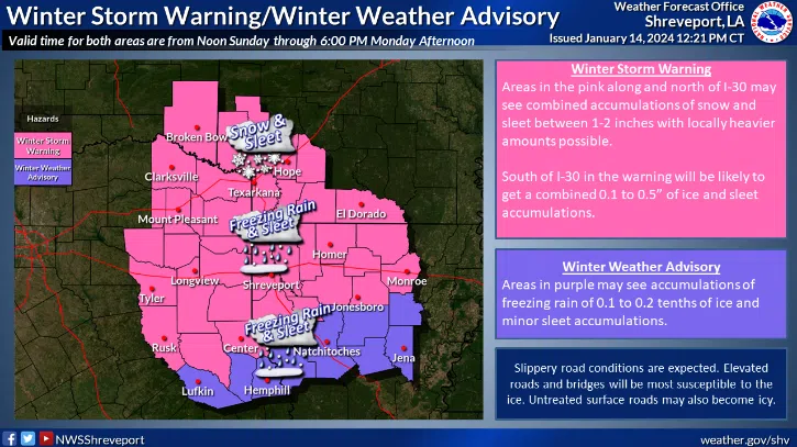
The entire I-20 corridor is under a winter storm warning as snow, sleet and freezing rain is expected to fall through the afternoon hours. Ryan Knapp is a meteorologist with the National Weather Service in Shreveport.
“We can see accumulations of sleet, freezing rain, really more sleet I would say, and snow up towards I-30 between about 1 to 2 inches, a little further south near I-20 you’ll see more of that freezing rain and sleet accumulation,” said Knapp.
There’s a chance for freezing rain for entire the state. It will be very light for south Louisiana. Knapp says central Louisiana could see one to two-tenths of an inch of freezing rain.
And it will be cold for the next few days. Highs for north Louisiana will be in the mid to upper 20s Monday. Central Louisiana will see highs near the freezing mark. Mid-40s for south Louisiana Monday.
Cameron Kowalski with the National Weather Service in Lake Charles says Tuesday will be the coldest day for south Louisiana.
“Really won’t get much above freezing for long on Tuesday, maybe just few hours that we climb above freezing for a few areas, mainly near the coast,” said Kowalski.
Kowalski says this storm system will also produce northerly winds of 20 to 25 miles per hour.
“When you feel that on the skin, combine that with temperatures in the 20s and 30s that makes it feel like its in the teens to some areas in the single digits,” said Kowalski.


Comments