


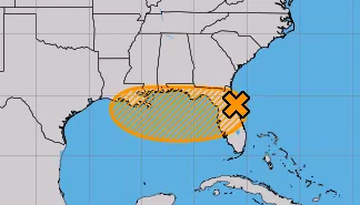
courtesy of National Hurricane Service
The National Hurricane Center says there is a medium chance for a tropical depression to form near Louisiana’s southeast coast later this week. LSU Public Health Climatologist Barry Keim says regardless of development, significant rainfall totals are expected.
“We could see anywhere from 10 to 15 inches of rain, you know, close to the coastline, and with widespread, four-to-five-inch totals across, you know, much of South Louisiana,” Keim said.
The rainfall will reach coastal parishes of southeast Louisiana on Wednesday. Keim says Thursday and Friday are the days we could see several inches of rain fall for a good portion of south Louisiana.
“It’s certainly going to be a rain event, not likely to be much of a surge or a wind event, but it’s still early, so we’ll just keep a close watch on it,” Keim said.
Southeast Louisiana is under a flood watch from tomorrow afternoon through late Friday night.
The disorganized system will cross the Florida peninsula today and enter the enter the northeastern Gulf of Mexico by tomorrow. Keim says its ability to organize into a named storm will depend on how long the center of the storm stays over water before making landfall along the northern Gulf coast. He says they are not expecting this system to develop into a hurricane.
“We’re looking at a pretty significant rain event. I still don’t anticipate this is going to be much wind or surge,” Keim noted.


Comments